

How ADS-B and AIS Illuminate the Full Counter-Drone Picture
The problem in many counter-drone operations isn't a lack of signals. It’s an excess of them. Distinguishing legitimate signals from illegitimate ones and knowing exactly what's in the air or on the water at any given moment is crucial for providing context and informing response.
Comprehensive and actionable intelligence requires a counter-drone approach that goes beyond RF detection. A sharper approach is to incorporate ADS-B and AIS awareness to account for known aircraft and vessels, so a clear overall picture can form.
Counter-Drone Environments are Saturated with Legitimate RF Traffic
Military environments, ports, airfields, and emergency response situations all generate a consistent barrage of electromagnetic activity from sources that have every right to be there. Being able to identify and contextualize that green-lit traffic is what creates the clarity required for security personnel to react appropriately.
In fast-moving situations, counter-drone operators may be dealing with transiting aircraft, registered vessels, emergency helicopters, police aircraft, or friendly drones. Every one of them needs to be accounted for.
The operator's job isn't to necessarily detect everything. It's to understand a dense and shifting RF environment, identify the signals that belong, and pinpoint those that don’t.
An operator flooded with alerts or confronted with a convoluted threat picture doesn't have more information. They have a higher cognitive load and a weakened ability to separate a real threat from background noise.
What are ADS-B and AIS?
| AIS (Vessels) | ADS-B (Aircraft) |
|---|---|
| The Automatic Identification System (AIS) performs the same function in maritime environments. Commercial vessels, coast guard ships, ferries, and most regulated maritime traffic broadcast their position, heading, identity, and speed continuously. An AIS-registered vessel is a known and trackable entity. One without an AIS signature is an immediate anomaly. | Automatic Dependent Surveillance-Broadcast (ADS-B) is the global standard by which aircraft broadcast their identity, position, altitude, and velocity. Widely mandated for commercial aviation in most jurisdictions, most legal aircraft operating in controlled airspace broadcast continuously. If a craft that should be transmitting isn’t, that’s a cause for focus and response. |
ADS-B and AIS Augment RF Intelligence
Neither AIS nor ADS-B systems were designed for counter-drone operations. But in tandem, they provide an authoritative, continuously updated reference layer of everything cooperative in the electromagnetic environment.
When an RF detection solution can cross-reference its detections against a known AIS/ADS-B layer, the complete operating environment can be visualized in real time on a Command-and-Control (C2) or Tactical Awareness Kit (TAK) display.
Moreover, when an anomalous signal is located, mapping its proximity to known air and sea platforms sheds light on the entire situation as it unfolds, giving even more context and oversight.
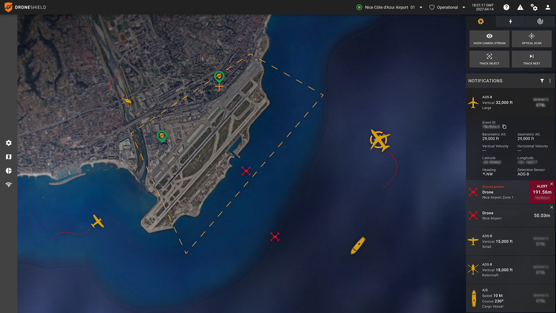
ADS-B and AIS signals reveal cooperative air and maritime traffic, distinguishing potential drones and contextualizing the counter-drone picture.
Giving RF Signals Context
The operational value of ADS-B and AIS integration comes from what it eliminates and contextualizes, not just what it detects.
In a busy port environment, a passive RF sensor will pick up dozens of signals simultaneously from maritime radio traffic and navigation equipment to crew devices. Without a reference layer, each signal represents a potential threat that has to be assessed. With a counter-drone solution that has AIS correlation running natively, every registered vessel's signature is automatically contextualized.
The same logic applies in the air. A forward operating base adjacent to a commercial flight path will see RF activity from transiting aircraft continuously. ADS-B correlation maps every cooperative aviation contact in real time. An RF signature without a matching ADS-B broadcast is a contact that warrants attention.
Context Informs Response
This goes beyond filtering. ADS-B and AIS build a more complete and accurate picture of the electromagnetic environment, turning isolated detections into operational intelligence.
A drone near an aircraft, helicopter or busy shipping lane warrants a different response from one operating in isolation. By providing visibility of cooperative air and maritime traffic, ADS-B and AIS help operators understand what is happening around a detection, not just that a detection has occurred. This may provide insight into an adversarial drone’s potential target.
That context supports more informed threat assessments and can change the urgency and nature of the response.
The Cost of Not Knowing
When an unidentified drone enters controlled airspace, the default response is often to shut everything down. Helicopters are recalled, aircraft are diverted, medical evacuations are delayed, and emergency responses are grounded.
Drone incursions have now become a regular disruptor of aviation in particular. In September 2025 alone, Copenhagen Airport and Oslo Airport both closed after large drone sightings, forcing major cancellations and reroutes. Munich Airport shut twice inside 24 hours that October, stranding thousands of travelers.
Drone incursions during wildfire and bushfire incidents in the U.S., Canada, and Australia have grounded firefighting aircraft, delayed aerial suppression efforts, and, in some cases, resulted in collisions with response aircraft.
The cost of not knowing can be significant. Every minute spent determining whether a contact is legitimate can mean delayed flights, disrupted emergency operations, or heightened security responses. In the absence of certainty, caution becomes the default.

ADS-B and AIS signals account for cooperative air and maritime traffic so a clear counter-drone picture can form.
Example Use Cases
A comprehensive counter-drone approach that combines RF detection with native AIS/ADS-B capability delivers broad intelligence across a range of typical environments.
Airfields and Airports
A drone enters the perimeter of a busy airport. Commercial aircraft are on approach, and ground vehicles and air traffic control systems are generating continuous RF activity. They all compete for attention and potentially mask the drone’s signals.
ADS-B correlation maps every legitimate aircraft by position, identity, and track. The moment a signal appears with no cooperative match, it can be isolated immediately. Operators know where the drone is, and ideally, its controller, and can escalate authority action to minimize impact on regular flight operations.
Port Security
A vessel transiting a busy shipping channel is broadcasting AIS, providing a verified position and identity. At the same time, an RF signature consistent with a drone control link is detected from the same location.
Correlating AIS and RF data associates the drone activity with a specific vessel rather than an anonymous contact. What would otherwise be an isolated drone detection becomes a contextualized event, identifying the vessel as a likely drone launch point. That’s intelligence that can be acted on.
Military Installation Near Civilian Airspace
A forward operating base sits in proximity to active commercial flight paths. When a drone appears near the installation’s perimeter, its control link appears among legitimate aviation traffic.
ADS-B signals map every cooperative aviation contact, broadcasting its position, identity, and track. The drone has none of these. Its control link appears against an otherwise cooperative picture as an unresolved contact.
Wildfire and Emergency Services
A fast-moving wildfire is in progress. Multiple water bombers, observation aircraft, and medical evacuation helicopters are operating in an exclusion zone. Meanwhile, a media drone or unauthorized civilian platform enters the zone to capture footage.
Every legitimate aircraft in that zone is broadcasting ADS-B and is visibly mapped. The unauthorized drone, with no cooperative aviation match, is the only unresolved contact in the picture. Ground teams receive its operator's approximate location and can act to ensure air operations don't cease and the wildfire receives primary attention.
Major Public Event
A stadium hosting a major event sits adjacent to a commercial waterfront. Law enforcement and news helicopters are hovering in the vicinity with commercial ferries and coast guard vessels operating in a nearby harbor. The RF environment is saturated with legitimate traffic.
ADS-B maps the aviation picture, while AIS maps the maritime picture. When an RF control signal appears from the shoreline with no cooperative match in either layer, the RF detection solution isolates it immediately. The operator isn't sifting through alerts, they're focused on the anomalous one and escalating the incident to authorities.
From RF Detection to RF Intelligence
RfRecon combines native ADS-B and AIS sensing with ultra-wideband RF detection, direction finding, and RfAI-3 AI-powered classification. Through ATAK or Command-and-Control displays, operators receive a single, correlated view of the air, maritime, and RF environments in real time.
As drone threats proliferate and operating environments become more complex, detection alone is not enough. Operators need to understand the entire environment before deciding how to respond.