

DroneShield Q3 Software Release Sharpens Counter-UAS Performance Against Faster, More Evasive Drone Threats
Sydney, Australia – 6 July 2026 – DroneShield today announced its Q3 2026 software release, delivering measurable improvements in RF detection performance, tracking responsiveness and operational capability across deployed DroneShield solutions.
The drone threat is evolving faster than at any point since we entered the market, and this release is a direct response to what operators are facing in the field:
Faster, more agile threats. FPV and coordinated multi-drone activity are compressing the time operators have to detect, identify and respond, placing a premium on track update speed.
Frequency-agile and evasive emitters. Adversaries are shifting across bands and using lower-power or less common protocols to avoid detection, driving the need for greater sensitivity and range.
Precision cueing. Operators increasingly need to coordinate effectors, cameras and complementary sensors onto a target, so localisation accuracy now has a direct effect on mission outcomes.
More contested, disconnected environments. Deployments are moving into GNSS-degraded, remote and air-gapped settings, driving the resilience and offline capabilities in this release.

Each quarterly release combines new capabilities with firmware enhancements that improve operational effectiveness while extending the value of hardware already in the field.
Testing against the previous Q2 release demonstrated significant gains across our RF sensing portfolio. Results depend on drone type and operating frequency.
Performance Advancements from 2Q26 to 3Q26
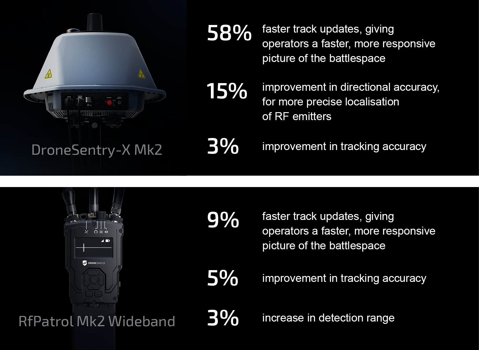
Results depend on drone type and operating frequency
"Our software roadmap is driven by operational outcomes," said Angus Harris, Chief Technology Officer at DroneShield. "Our quarterly releases focus on measurable engineering improvements that operators can put to work immediately. Whether it's faster tracking, greater localisation accuracy or new operational capabilities, each release strengthens the performance of deployed systems while building on the improvements delivered in previous quarters."
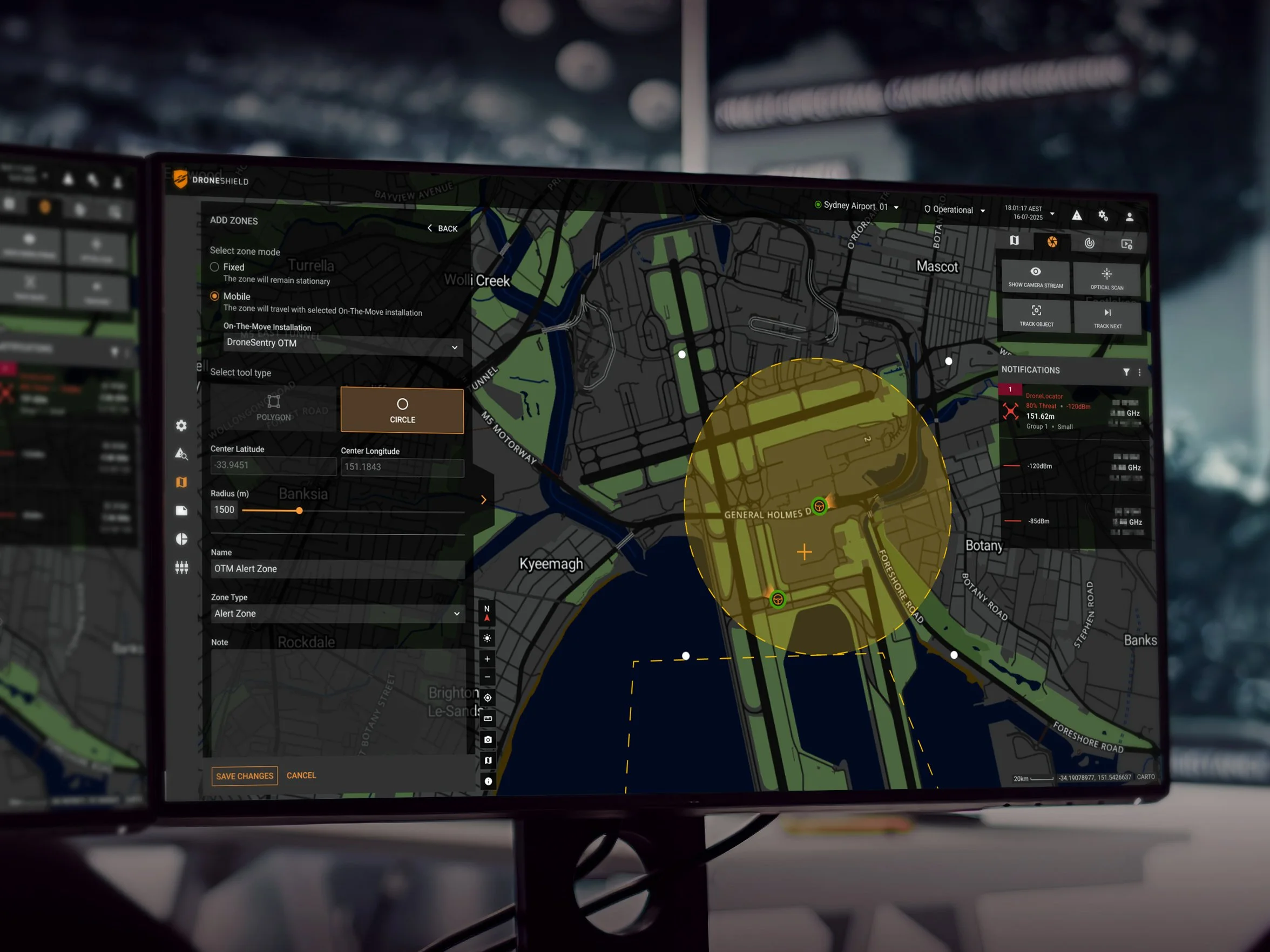
Image: Operators can configure Fixed or On-The-Move zones in DroneSentry-C2.
The Q3 release introduces several significant capability enhancements to DroneSentry-C2 including:
Air-Gapped Updates: customers on disconnected or highly secure networks can update independently using removable media, reducing reliance on remote support and simplifying lifecycle management for classified and sovereign environments.
Cloud Optimised GeoTIFF (COG) maps: load your own offline mapping into DroneSentry-C2, for greater flexibility in remote locations, overseas deployments, or environments where commercial mapping is unavailable or unsuitable.
Expanded Interoperability:
SentryCompass support, delivering resilient positioning through dual GNSS receivers with inertial navigation fallback
Robin Radar IRIS On-The-Move support, for mobile radar deployments
Evica PinPoint Searchlight support, for improved visual target identification in low-light conditions
Broader third-party sensor support via DroneSentry-C2's generic sensor framework
Additional language support: Dutch, German, Ukrainian and Japanese
These additions give customers greater flexibility to incorporate DroneShield solutions into existing sensor architectures while continuing to expand operational capability.
The Q3 2026 software release is available now through the DroneShield Access Portal for eligible customers with active subscriptions.